#3279: Main Span
Permalink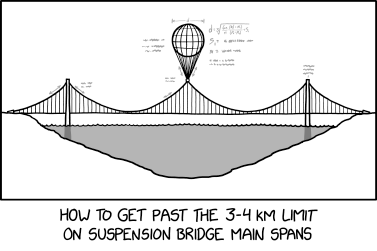
Transcript

|
This is one of 27 incomplete transcripts: Don't remove this notice too soon. If you can fix this issue, edit the page! |
[A diagram of a suspension bridge across a cross-section of a body of water is shown. The bridge has three spans. The left and right spans are held up using normal pillars that bury into the ground under the shallow portions of the water. The middle span has no pillar, and is held up by a large balloon tethered to the top of the tower by about a dozen cables. There are two-headed arrows above the main cables to the left and right of the left tower, to the left of the middle tower, and to the left and right of the cables from the balloon to the middle tower. There are mostly unreadable annotations to the right of the left tower (diagonally above the arrows), to the left of the middle tower, and to the left and right of the balloon. Above the balloon is a line segment whose length matches the width of the balloon with the annotation "d" in the middle. To the right of the balloon is an equation for d, written in small gray text.]
[Caption below diagram:]
How to get past the 3-4 km limit on suspension bridge main spans


(Sourced from explainxkcd.com)
Title text:Wind stress? Don't be silly. When has wind stress ever been a problem for a suspension bridge?